
|
|
|
|
The purpose of this study is to develop a Geographic Information
Science (GIS) and Remote Sensing database for the Southern Basin of the Niagara
Escarpment. To help aide in this process of building a database, a general
land use classification must be run in order to determine other areas of
interest. The main focus areas are several mounded regions, most likely
the remnants of glacier till. In the center of the image below are the
two ridges in which these particular Dark Green-Forest Light green-Other Veg. Yellow-Build-up Blue-Water White-Cloud Gray-Cloud shadow Red-Residential These ridges are located between Highland and Adams counties. Since the ridges have distinct features compared the surrounding area, these are the focus features we would like to include into our database. We will be able to depict these features in our GIS database will layers such as; soils, geology, elevation, hydrology and others as they arise. The tools which will be of the most use to our study will be the data collected and digitized by the Ohio Department of Natural Resources and the Geological Survey. These key components will be discussed in the Future/Conclusions section. The entire purpose of this study is to depict this feature as a distinct and prevalent landform in the Southern Ohio area. Also, this may become a pilot project for the mapping of the Northern portion as well. This portion of the project was to develop a way to characterize the landscape according to the general landscape/use of this section. This type of study has never been done before, at least in Southern Ohio. Our objective is to depict this feature using the various maps produced using Arc GIS. This will be conducted this summer with an educational grant from the University of Toledo. This grant was awarded to Dr. Patrick Lawrence, Sylvia-Linda Kaktins and Adam DeMars (the creator of this site). The Undergraduate Summer Research and Creativity Activity Program is sponsored by the Research Department at the University of Toledo.
|
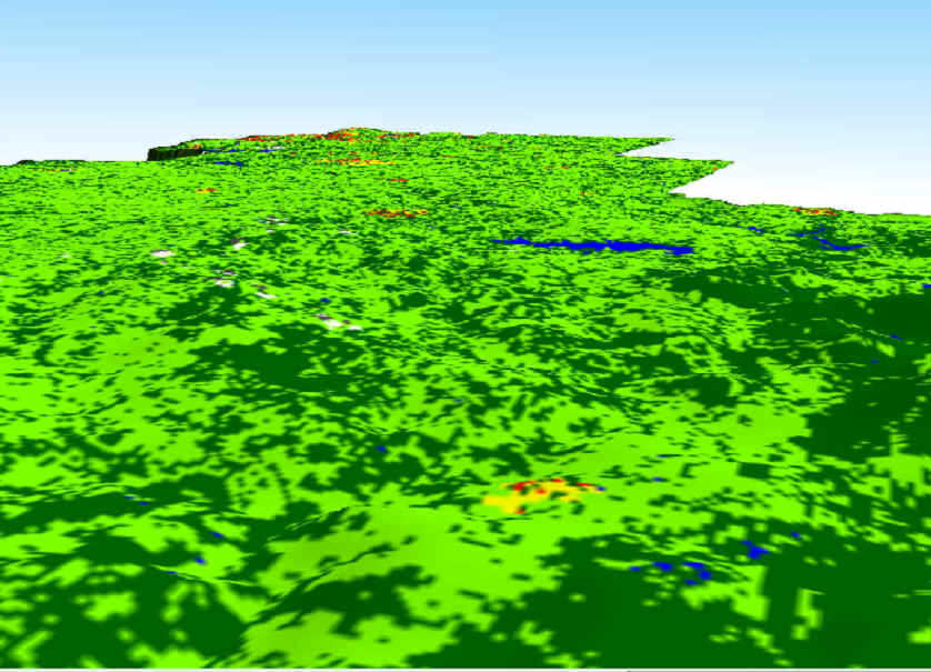 features
stand out. This images was created using an unsupervised 7-class
classification and a Digital Elevation Model (DEM). The DEM was exaggerated
10 times to depict the relatively flat landscapes of Ohio.
features
stand out. This images was created using an unsupervised 7-class
classification and a Digital Elevation Model (DEM). The DEM was exaggerated
10 times to depict the relatively flat landscapes of Ohio.