


|
|
|
|
To conclude this portion of the project, the overall classification are the numbers for the Accuracy Assessment using ERDAS Imagine software. The total does not reflect any ground truthing data. However, in the near future, ground truthing data will be provided to reclassify the area according to the different agricultural types. Conclusion To create an accuracy assessment of image, a minimum of 50 sample points per class (Congalton, 1991) is suggested and it is also suggested in John R. Jensen's, Introductory Digital Image Processing A Remote Sensing Perspective. In the classified image of Southern Ohio, I used 500 sampling points. The number of points that I used definitely exceeds the number of 50 per class. Remember, I have not been ground truthing, therefore, once I have created at least 100 ground truthing points and have reclassified the image based on those new points/classes, I will need to redo the assessment. At the bottom of this page you can view the total accuracy assessment.
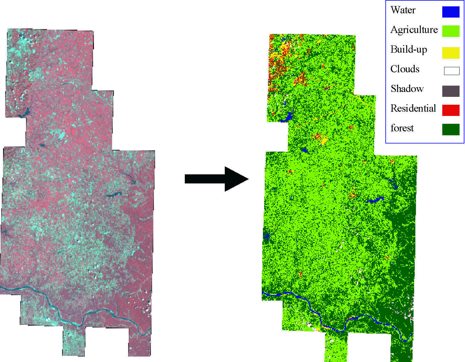
Above the original August Path 19 Row 33 and Path 20 Row33 images mosaiced together. On the right is the classified image according to the 7 classes. Breaking the image into subsections, such as the cities and clouds, helps to eliminate problems with mixed pixel classes. One of the most difficult portions of this classification is the Residential areas. Due to the trees, grass and concrete areas, these pixels tend to give rise to miss classification problems. However, a majority of this problem was solved by subsetting the cities out of the image and classifying them separately. Notice the darker swath on the original false color image, this is Path 20 Row 33. In order to finish this classification, both Path 19 and Path 20 must be recoded together in order to merge the two images together. This process caused some problems because I have never had to do this before. To help me with this problem I would like to thank Mike Palmer, Graduate Student, Geography and Planning, for showing me the correct way.
Within these classification percentages, Forest, Residential, Build-up, and Agriculture need to be improved. Ground truthing and having validation points for the future classification should help these problem classes out. The main concern was the Residential class. As stated before, Residential areas tend to have a lot of mixed pixel values. This will cause a problem within the overall classification of the image. Moreover, I feel that subsetting out the Cloud and Shadows and the Build-up areas, greatly increases the classification. Lastly, since the classification did not achieve the 85% accuracy, changes and ground truthing need to be done in order of this to be a contributing factor within the GIS database. The process used in this method has helped my skills in the numerous techniques used for classifying images based on land use features. |