 The
The•Summer Teacher Workshops
Summer Teacher Workshop and Observation Program.
Global Change and Remote Sensing.
•Research for Undergraduates
Funded summer research opportunity for undergraduate students.
This is our fourth year of this NSF program.
•S~A~T~E~L~L~I~T~E~S
Observing Earth from Space.
Class Information:
Digital Image Analysis
Geography and Planning 4500/5550
This is the follow on class for Environmental Remote Sensing. This class will focus on the tools and data
involved with digitalMAGINE, ArcView Image Analyst and Multispec.
Environmental Remote Sensing
Geography and Planning 4490/5490
This is an introduction to the prinhe class concerns include an introduction of the energy, devices,
and processing required to extract information from remotely sensed imagery
Analytical and Computer Cartography
Geography and Planning 4520/5520
This class introduces the student to the practical and applied of digital cartography. Using historical
and computer assisted cartographic method the student will take away a valuable skill for application
in employment and research.
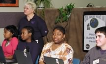
K-12 Student Observation Program: