
| UTView Research At the University of Toledo's Geography and Planning Department we are committed to research. Below is a list of the research projects we are pursuing or have completed. |
||||||||||||||||
|
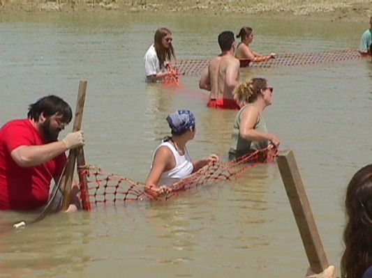
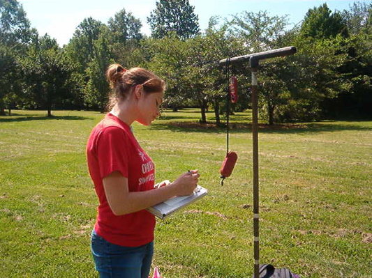
Integrated Assessment of Physical, Ecological
and Socio-economic Aspects of a Watershed System Funding Agency: NSF (SES 0243872) Contact: Kevin Czajkowski, 419-530-4274, kczajko@utnet.utoledo.edu We will provide a summer research opportunity which will 1) educate students regarding the interconnected nature of hydrological processes, water quality, demographics/economics, land use practices, riparian ecosystem quality, sediment contamination, and the legal/policy implications of river ecosystem degradation, 2) mentor students in research projects focused on the Maumee River and Lake Erie health from environmental, biological, social and policy perspectives and 3) encourage students to pursue careers in science. |
||||||||||||||||
 |
 |
 |
||||||||||||||
|
Use of Thermal Infrared Satellite Data in Climate Change Studies
Funding Agency: NASA (NAG-5-8671) Dr. Kevin P. CzajkowskiJames Coss, Teresa Benko, Janet Struble, Jessica Rose, Stephen Mather Thermal infrared (TIR) remotely sensed data from the Advanced Very High Resolution Radiometer (AVHRR), and the Geostationary Operational Environmental Satellite (GOES) and the soon-to-be launched Moderate Resolution Imaging Spectrometer (MODIS) are potential sources of land surface temperature (LST) data for use in global climate monitoring and Earth System Science applications. |
||||||||||||||||
|
Land Surface Environmental Conditions from Satellite Imagery
Funding Agency: NASA (NAG-5-8052 and NAG-5-8671) Dr. Kevin P. Czajkowski James Coss, Teresa Benko, Janet Struble, Jyothy Nagol, Stephen Mather One of our main research focuses in the Department of Geography and Planning at the University of Toledo is the estimation of land surface environmental conditions from satellite observations, particularly from thermal infrared remote sensing. |
||||||||||||||||
|
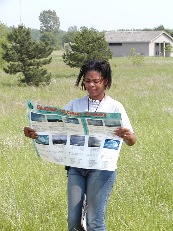
GLOBE Program
Funding Agency:NSF (GEO-0222905) Dr. Kevin Czajkowski, Dr. Alison Spongberg, Dr. Mark Templin, Janet Struble, Teresa Benko, Timothy Ault, James Coss - U of Toledo. Jackie Kane - St. Ursula Academy, Toledo We plan to take responsibility for the cloud cover and type, snow, air temperature, soil temperature and soil moisture protocols and the continuous air and soil temperature protocols.... Also, under this proposal, we will develop and test a new protocol to observe surface skin temperature, i.e. the temperature of sidewalks, parking lots, leaves, grass, bare ground as determined by the electromagnetic energy they emit.... Specifically, students will be able to investigate the urban heat island effect and the effects of clouds, snow and soil moisture on the surfaces absorption of energy. |
||||||||||||||||
 |
 |
 |
||||||||||||||
|
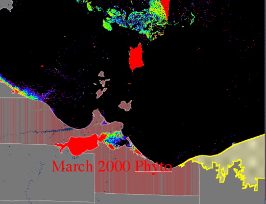
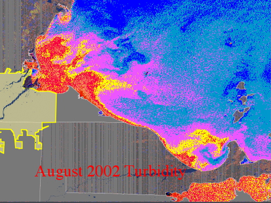
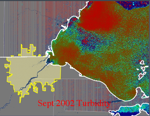
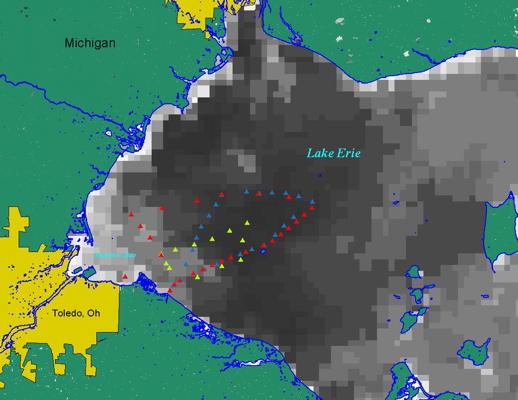
Development and Validation of a Turbidity Product for Lake Erie:
GLERL's CoastWatch Satellite Program Funding Agency: NOAA Kevin Czajkowski and James Coss, University of Toledo Although the clarity of the Great Lakes has improved dramatically over the last 30 years, erosion, sediment (non-point source pollution) and sediment transport still remain a significant environmental problem for decision makers....It uses the Advanced Very High Resolution Radiometer (AVHRR) to produce water temperature and visible reflectance products, RadarSat for ice detection, SeaWifs for ocean color monitoring and Geostationary Operational Environmental Satellite (GOES) satellite images for cloud monitoring over the Great Lakes. |
||||||||||||||||
 |
 |
 |
 |
|||||||||||||
|
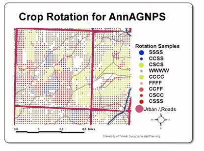
Army Corps of Engineers, Upper Auglaize Non-point Pollution
Funding Agency: Army Corps of Engineers PI: Kevin P. Czajkowski, University of Toledo Co-I: Patrick Lawrence, University of Toledo Co-I: Carolyn Merry, Ohio State University James Coss, Michael Palmer, Mark Fedders, University of Toledo Considerations of a long term sediment modeling initiative by the Army Corps of Engineers/US Geological Survey/NRCS include continued building of watershed databases/monitoring of the drivers of a watershed model, expanded monitoring of sediment pollution, and determination of the fate of sediments (as well as implications for contaminant transport and ecological impact of sediments/pollutants). |
||||||||||||||||
 |
 |
|||||||||||||||
|
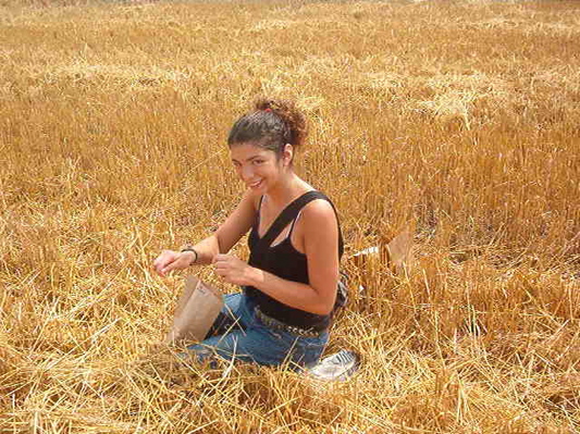
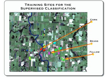
Agricultural Land Use Mapping with Multi-Temporal Imagery
Funding Agency: Great Lakes Commission Kevin Czajkowski and James Coss The Portage and Sandusky River drainage basins do not have an accurate, comprehensive, complete and current geographic databases of land use and land cover that are needed for the watershed partnerships to effectively use in making planning decisions about their watersheds. Furthermore, both the Portage and the Sandusky watersheds have been identified as significant sources of sediment and are listed as watersheds of special significance by the Army Corps of Engineers and the Sandusky watershed is slated by the Army Corps to be modeled under the 516 program. |
||||||||||||||||
|
Integrated Assessment of Physical, Ecological
and Socio-economic Aspects of a Watershed System Number of Students: 12
|
||||||||||||||||
|
Use of Thermal Infrared Satellite Data in Climate Change Studies
PI: Dr. Kevin P. Czajkowski ABSTRACT |
||||||||||||||||
|
Land Surface Environmental Conditions from Satellite Imagery
Funding Agency: NASA (NAG-5-8052 and NAG-5-8671) One of our main research focuses in the Department of Geography and Planning at the University of Toledo is the estimation of land surface environmental conditions from satellite observations, particularly from thermal infrared remote sensing. Surface temperature, near surface air temperature and near surface water vapor are of critical importance to the study of terrestrial hydrology (Dubayah et al. 2000), biospheric processes (Prince and Goward 1995) and other Earth System Science processes (Ehrlich et al. 1994). |
||||||||||||||||
|
GLOBE Program
Funding Agency: NSF (GEO-0222905) Engaging students and teachers as scientists is a goal of GLOBE. We propose to engage GLOBE students in research projects associated with the Energy Cycle and the Earth. We will build off our team's recent experiences training teachers in summer workshops, holding GLOBE workshops and carrying-out student centered research projects. Much of our work with teachers and students focuses on local schools in Northwest Ohio and regionally to Michigan, Pennsylvania and the rest of Ohio. Under this GLOBE proposal we will extend our experience to reach students and teachers on an international level. Our focus on the energy cycle will allow us to develop student research activities that integrate the earth as a system. We plan to take responsibility for the cloud cover and type, snow, air temperature, soil temperature and soil moisture protocols and the continuous air and soil temperature protocols. We plan on creating new learning activities using the new and existing data for classroom extensions. We will look at several of these protocols to determine if they need to be modified to address teacher suggestions as well as enhance their scientific application. For example, we plan to explore probes to measure soil temperature at deeper sampling depths than currently used. We anticipate that the deeper observations will show the students a larger change in temperature. Also, under this proposal, we will develop and test a new protocol to observe surface skin temperature, i.e. the temperature of sidewalks, parking lots, leaves, grass, bare ground as determined by the electromagnetic energy they emit. This surface temperature is at the center of the energy cycle because it is influenced by incoming solar radiation as well as the properties of the surface and subsurface. The surface temperature protocol will be especially useful by inner-city schools with limited natural space. Scientifically, all of these protocols are linked through the Earth's energy cycle. We currently are conducting scientific investigations using GLOBE student data. In particular, we are validating the snow detection algorithm and cloud screening technique from the Moderate Resolution Imaging Spectroradiometer (MODIS) on the Terra satellite. We propose to extend this research under the GLOBE grant to include validation of surface temperature from satellite. Dr. Czajkowski has worked on surface temperature validation for six years and has published several journal articles on the topic. Finally, we will assist schools in developing research questions of their own. Specifically, students will be able to investigate the urban heat island effect and the effects of clouds, snow and soil moisture on the surfaces absorption of energy. By monitoring soil temperature with depth the transfer of heat and energy from the surface into the ground can also be investigated. The temporal data that this new area will obtain will provide valuable data for evaluating global changes in the climate and environment. This presentation was prepared by Kevin Czajkowski, Tim Ault, Terri Benko, and Takelia Bragg, all of the University of Toledo. |
||||||||||||||||
|
Development and Validation of a Turbidity Product for Lake Erie:
GLERL's CoastWatch Satellite Program Kevin Czajkowski and James Coss, University of Toledo Rationale |
||||||||||||||||
|
Army Corps of Engineers, Upper Auglaize Non-point Pollution University of Toledo PI: Kevin P. Czajkowski, University of Toledo Collaboration with: |
||||||||||||||||
|
Agricultural Land Use Mapping with Multi-Temporal Imagery
Kevin Czajkowski and James Coss
|
||||||||||||||||
|
Maumee Watershed Geographic Information System (GIS) and Remote Sensing Project
Dr. Kevin Czajkowski, Dr. Patrick Lawrence, James Coss, Phil Haney, Katie Swartz, and Rumiko Hayase Funding Agency: Visit the website for this project... As of October 2005, the USDA Natural Resources Conservation Service (NRCS) has entered into a five year Memorandum of Understanding with the Geographic Information Science & Applied Geography (GISAG) Research Center of the Department of Geography and Planning at the University of Toledo, Ohio. Work performed will assist NRCS in implementing the Maumee Watershed project, including sub watershed rapid resource assessments, watershed and area planning, on farm conservation planning and delivery of conservation technical assistance and conservation cost-share programs authorized by the 2002 Farm Bill that are of mutual interest to University of Toledo and NRCS. |
||||||||||||||||